These 8 Colorado Springs hikes are a great intro to the Rockies

Jan 15, 2025 • 8 min read

From easy walks to glute-busting ascents (like the Manitou Incline), many hikes lie within a short distance of downtown Colorado Springs. Jeremy Hudson/Shutterstock
From walks in the park to ascents up a fourteener, Colorado Springs has numerous hiking trails to suit all interests and athletic abilities.
Since this eastern Colorado city is nestled at the foot of the Rockies, you don’t have to travel far from downtown to encounter beautiful red rocks, towering waterfalls and otherworldly terrain. Indeed, such excursions in nature are some of the city’s top draws. The hard part will be determining which way to go first; the good news is you can’t go wrong.
With a choices for families, casual walkers and advanced mountaineers, these eight hikes will help you get in your steps – and then some.
1. Manitou Incline
Best for hiking enthusiasts and athletes
1 mile round trip (1609m), 2000ft (609m) elevation gain, 1 hour, challenging
For hikers looking for a fun challenge and a serious glute workout, the Manitou Incline is calling your name. It’s 2768 steps to the top – and a rite of passage for many. This path was originally cleared to lug materials to build pipelines on Pikes Peak via a cable car; once the pipelines were complete, it became a tourist attraction.
The path up is not for the faint of heart: expect steep inclines with an average grade of 45%, and up to 68% in some places. At this high altitude, it can anywhere from under 30 minutes to over an hour less to reach the top, depending on your fitness level. Successful hikers are rewarded with a view of Colorado Springs and the eastern plains. If your thighs object midway, you can bail out early on the Northern Incline Return Trail, which all hikers take on the way down.
Planning tip: While the Manitou Incline is free, online reservations are now required to manage crowds, so consider using the free Manitou Springs shuttle to avoid competing for a parking space.

2. Mesa and Yucca Trail Loop
Best sunset walk
2.7 miles (4345m) round trip, 262ft (80m) elevation gain, 1–2 hours, easy
For gorgeous views of the front range with the city below, head northeast of Colorado Springs to Palmer Park. You’ll be surprised by the unique terrain of this urban green space, which brings you up into the mountains while remaining within the city limits. The drive along Paseo Rd winds to the top, where you’ll find a gravel road leading to a parking lot and trailhead for the Yucca Flats. Follow the Mesa and Yucca trails, a loop offering beautiful wildflowers and interesting scenery for all skill levels – not to mention amazing views of the Rockies.

3. Paint Mines Interpretive Park
Best hike for adventurers
3.4 miles (5472m) round trip, 500ft (152m) elevation gain, 2–3 hours, easy
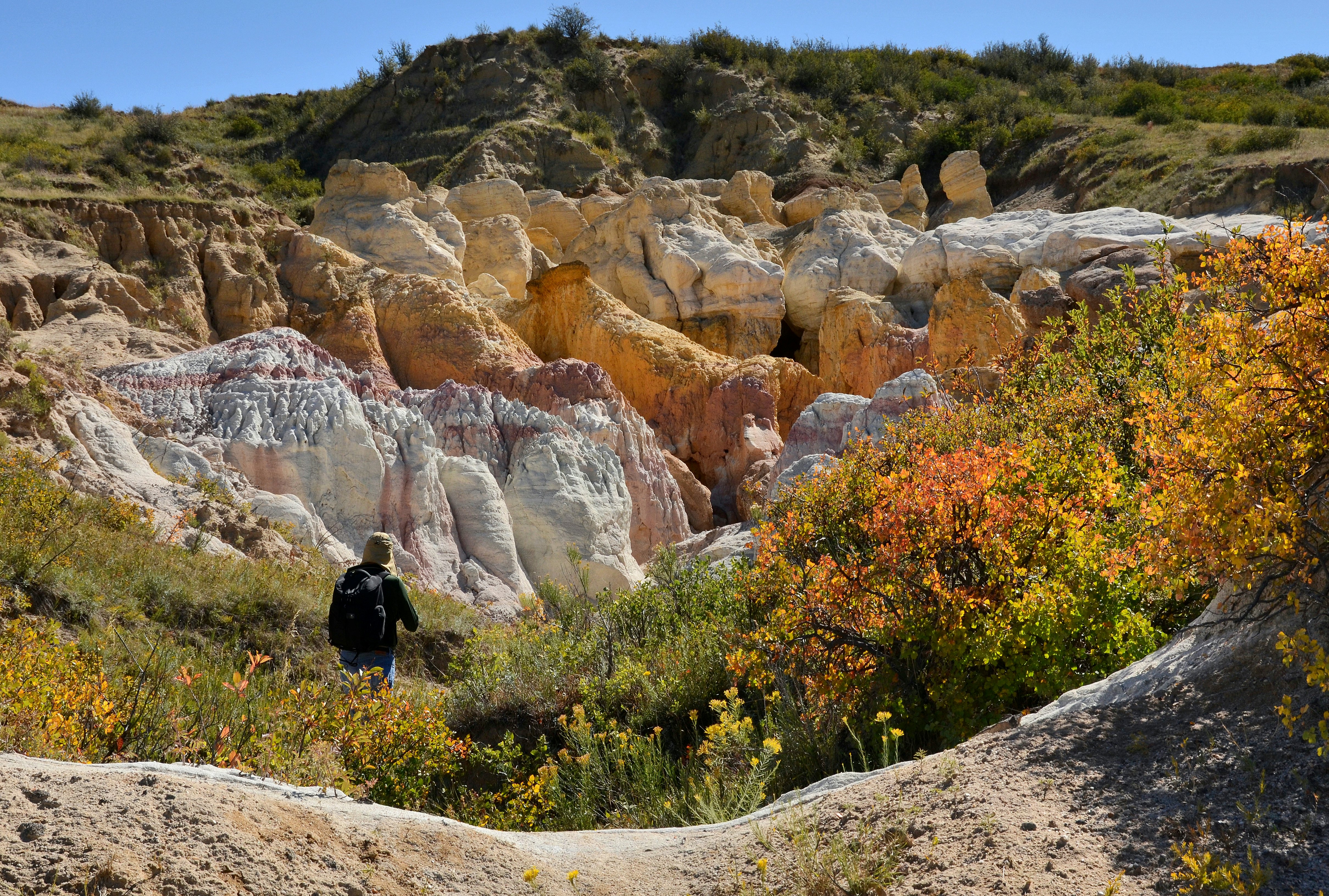
A visit to the Paint Mines Interpretive Park will get you off the beaten path. About 30 miles (48km) east of Colorado Springs, this park makes you feel like you’re on another planet. Its rare geological formations are stunning, with sandstone-capped spires called hoodoos that can only be found in three regions of the country.
The park was named for its colorful bands of white, orange and pink clay, once used by Native Americans to make paint. Feel free to explore and wander along the trail (though climbing the structures is not allowed), and be sure to visit the overlook for an interesting vantage point. For the best light, rangers and photographers recommend coming early or late in the day, when the colors appear more vibrant.
Planning tip: There are limited facilities on site, including one picnic table and a restroom near the main parking lot. There’s no shade, so bring a hat, sunscreen and plenty of water. Bikes, dogs and horses are not allowed.

4. Seven Falls Waterfall and Midnight Falls Hike
Best hike for sightseers
0.8-mile (1287m) walk to waterfalls and a 224-step staircase, 2–4 hours, easy
This easy walk, up a 224-step staircase leading to the top of the waterfall, will surround you in nature and open up views of the famous Broadmoor resort. From here, you can choose from two hikes, Midnight Falls or Inspiration Point. At .4 miles (580m) one way (about 30 minutes round trip), Midnight Falls is the shorter of the two, a mellow walk through the woods leading to a small waterfall. Inspiration Point is about 1 mile (1610m) and an hour (round trip) to a lookout offering views of Colorado Springs. From the bottom of the falls, you can also take an elevator to an observation deck to further admire the falls.
While Seven Falls is open year round, check the website for current operating hours; the trail is closed in the winter. All the beauty doesn’t come cheap, with tickets $23 per adult (and discounts for children, seniors and military members).
Planning tip: While there's no parking at the entrance for Seven Falls, free parking and shuttle-bus service is available for visitors at the Norris Penrose Event Center. In the summer, plan to park 30 minutes before it opens to avoid waiting in a long line.

5. Helen Hunt Falls and Silver Cascade Falls Trail
Best hike for waterfalls
.6 miles (965m) round trip, 175ft (53m) elevation gain, easy to moderate
As soon as you step out of the car in North Cheyenne Cañon Park, you can admire the view of spectacular Helen Hunt Falls. The upper parking lot next to the visitors’ center is where this trail begins. From there, take a short walk over a bridge spanning a waterfall, then continue up the mountain for a nature hike to a second waterfall.
Silver Cascade Falls Trail is well maintained, with handrails and graded steps on the trek up to the taller of the two cascades. Along the way, you’ll see water splashing off the rock, as well as two viewpoints. While it’s challenging to get a good look at the Silver Cascade Falls from the top, the main observation point offers an exciting peek at North Cheyenne Cañon.
6. Seven Bridges Trail
Best for adventure seekers
5.78 miles (9302m) round trip, 1597ft (487m) elevation gain, 2–3 hours, moderate
The Seven Bridges Trail will appeal to any hiker looking for an immersion in nature. The route is sure to keep you guessing, wondering when you’ll discover the next bridge as you try to check them all off your list. The path offers a shady escape in the heat of the summer – though the hiking here is best in winter when the snowpack is low.
Driving through North Cheyenne Cañon, you’ll find a parking lot on the west end; from there, you’ll begin walking up Lower Gold Camp Rd, a former narrow-gauge railroad bed that’s now a dirt road. The first bend in the trail is where the Seven Bridges Trail begins – look for a marker on the righthand side indicating Trail 622. From here, you’ll dip into the forest, following along the creek to discover the seven numbered bridges. The first and second come early in the adventure; continue on to discover all seven. The last bridge ends at Jones Park, where you’ll find a variety of other trails if you’re still up for more.

7. Barr Trail
Best advanced hike
12+ miles (19+km) one way, 7800ft (2377m) elevation gain, 6–10 hours, challenging
For those looking for an advanced hike, challenging Barr Trail leads to the summit of Pikes Peak. Nicknamed America’s Mountain, the famous fourteener draws many visitors who arrive by car or cog railway. Yet true hikers love a good challenge when they see it – and indeed, Barr is a 12-mile (19km) trek with a 7800ft (2377m) elevation gain. Be sure to dress in layers to prepare for weather and bring plenty of snacks and water.
Summer and fall are the most popular times to embark on the Barr Trail to avoid serious snow. While most people wake up early to get a head start (and to avoid afternoon storms at the summit), overnight camping is available for those who want to make it a two-day hike. Barr Camp is 6.5 miles (4km) in and offers indoor seating, picnic tables and clean restrooms. Be sure to coordinate transportation for the way back down, whether from a friend with a car or a ride on the Broadmoor Manitou and Pikes Peak Cog Railway to Manitou Springs.

8. Garden of the Gods
Most iconic hike, and easiest hike for all ages
1.5 miles (2414m) round trip, less than 30ft (9m) elevation gain, easy
No trip to Colorado Springs would be complete without a visit to Garden of the Gods, which is easy to access and free year-round. While you can loop around the park by car or dive in deeper with a Segway, e-bike or climbing tour, most travelers start with an easy walk along the Perkins Central Garden Trail, a paved path that leads through and around the tallest of the park’s famous red-rock formations. More than a dozen trails beckon here; if you have time to walk only one, the Central Garden Trail gives you the best lay of the land.
Tips for hiking in Colorado Springs
Keep in mind that the region is around 6000ft (1830m) above sea level, and the air is both thin and dry.
Bring a water bottle to stay hydrated, minimize your alcohol intake and wear sunscreen – the rays are powerful here.
Out-of-towners may need a day or two to acclimate to the high altitude, so avoid physical exertion to ease into it.


