Advertisement

A backpacker in Little Lakes Valley, John Muir Wilderness in California. Jimmy W/Shutterstock
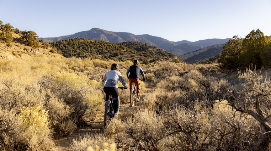
From the windswept beaches of northern California to the remote barrier islands of coastal Georgia, the terrain for backpacking trips in the United States is wild and varied. Between the coasts long-distance hikers will find campsites tucked near red rocks, alpine lakes and snow-capped peaks and hugged by miles and miles of forest.
And if you ask 1000 thru-hikers to list their favorite routes, you’ll hear 1000 different answers. I’ve included below seven great backpacking trips. These routes are based on suggestions from park rangers, backpacking veterans and my own experience exploring more than 34 national parks and scads of public lands. But no matter where you pitch camp, there are few things better than a hot cup of coffee on a crisp, clear morning in the wild.
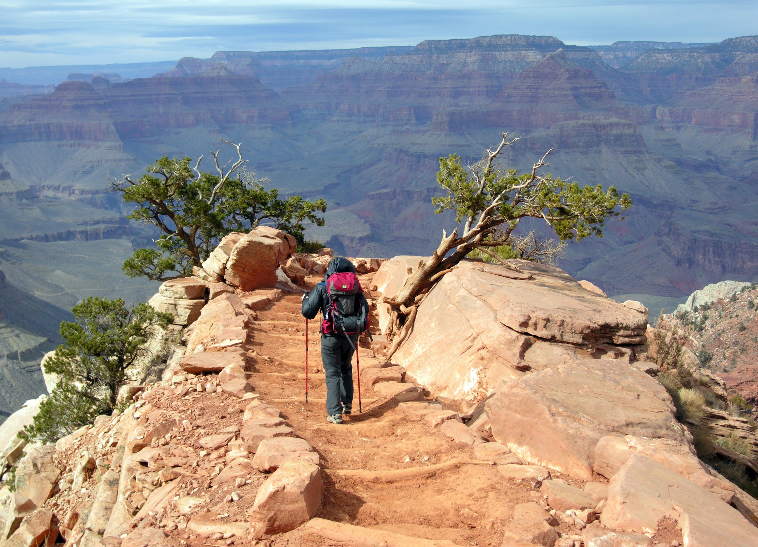
1. Grand Canyon National Park: South Kaibab and Clear Creek Trails
Best for geology and amazing views
Advertisement
Start and end: South Kaibab Trailhead
Length: 32.2 miles round trip
Time commitment: 5–6 days
Difficulty: strenuous
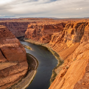
One billion years of geologic history flashes past on this plunge into the Grand Canyon. Soaring canyon walls and majestic rock formations await around every bend while cottonwood trees provide shade and gentle beauty along Bright Angel Creek. From the South Rim, the South Kaibab Trail drops past Ooh Ahh Point and Panorama Point before crossing the Colorado River. East of Phantom Ranch, the Clear Creek Trail overlooks Granite Gorge with spectacular views of the river corridor. Zoroaster Temple commands attention as you close in on Clear Creek.
Camp at Bright Angel Campground on your way to Clear Creek and on your return. We recommend snacks, beer and the communal vibe at nearby Phantom Ranch. A two-night stay in the Clear Creek Use Area gives you time for a day hike to Cheyava Falls or the Colorado River. For variety, return to the South Rim on the Bright Angel Trail (note that the connecting River Trail is closed for repairs through the fall of 2025).
Where to stock up: Buy groceries and gear at Canyon Village Market & Deli on the South Rim.
Need to know: Due to heat and exposure, this trip is best tackled between October and mid-April. Permits can be hard to secure, so start planning a year in advance.
Wrapping it up: Kick back with prickly pear margaritas and hearty chili at El Tovar Lounge on the South Rim.
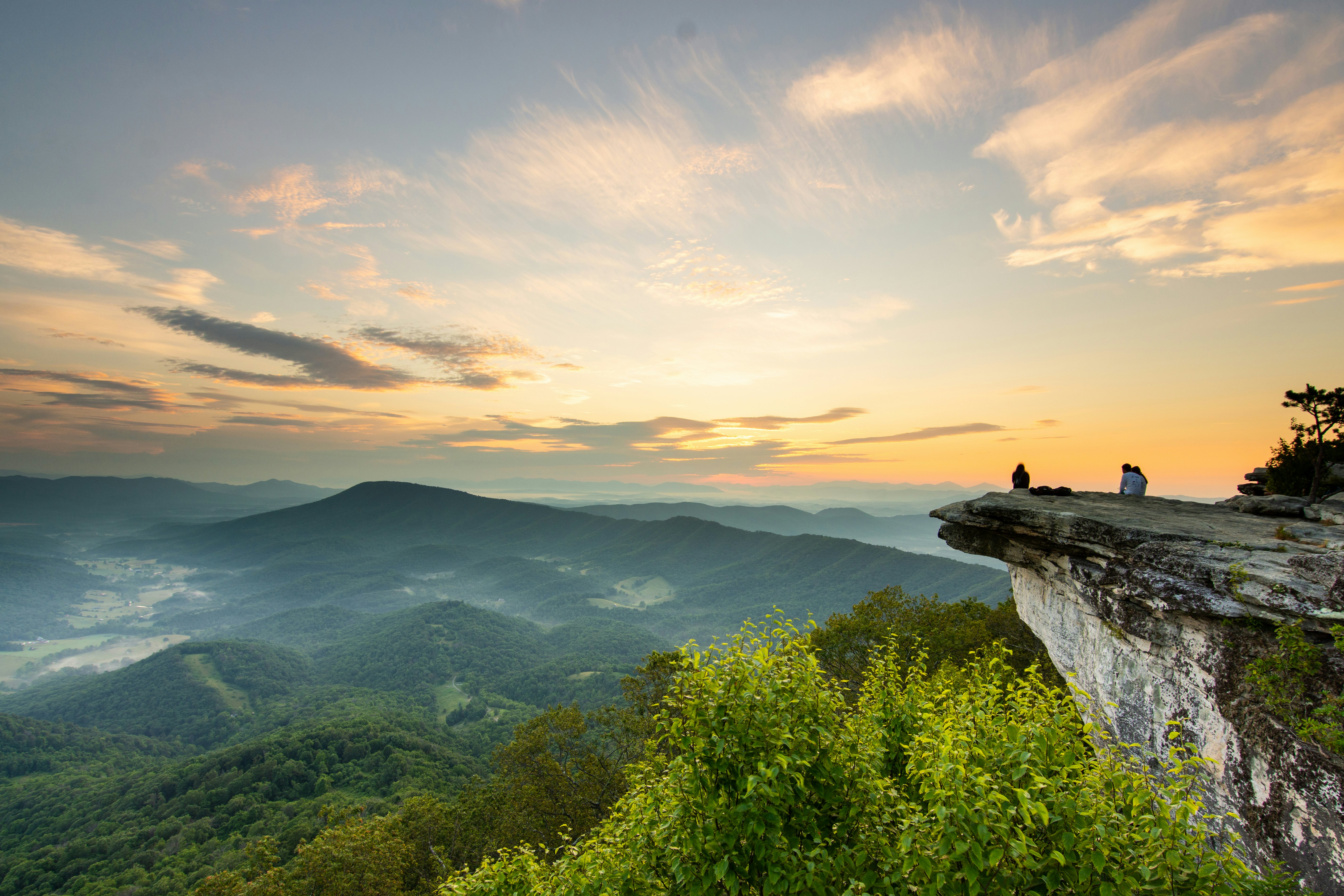
2. Appalachian Trail: Virginia’s Triple Crown Loop
Best for a quick urban escape
Start and end: McAfee Knob Parking Area, Catawba, VA
Length: 35 miles
Time commitment: 3 days
Difficulty: strenuous
Three of the most iconic sites on the Appalachian Trail (AT) – McAfee Knob, Tinker Cliffs and Dragon's Tooth – hug this hard-charging loop that is in the Blue Ridge Mountains within a half-day’s drive of Washington, DC and much of the Mid-Atlantic. The famous McAfee Knob is one of the most photographed spots along the entire AT. It’s easy to see why: this narrow ledge juts out over the Catawba Valley like an unfinished footbridge. It’s just wide enough for a handful of hikers to strike a dramatic pose for a photo.
Parking lots and campsites border this forested mountain loop, making it easy to build your own adventure. Many backpackers start at the McAfee Knob Parking Area then follow the AT to McAfee Knob and Tinker Cliffs before linking to the Andy Layne, North Mountain and Dragon’s Tooth Trails.
Where to stock up: For groceries, drive to Kroger in the city of Salem 8 miles from the trailhead.
Need to know: You cannot camp at McAfee Knob or Tinker Cliffs, but there are seven designated camping areas nearby. Dispersed camping is permitted in Jefferson National Forest near Dragon's Tooth. The helpful Roanoke Appalachian Trail Club website shares details about camping and trail access points.
Wrapping it up: Enjoy food truck fare and an IPA at Parkway Brewing in Salem.

3. California: Lost Coast Trail
Best for wildlife
Start and end: Mattole Campground/Black Sands Beach at Shelter Cove
Length: 24.6 miles
Time commitment: 3 days
Difficulty: moderate
Advertisement
Don’t pester the elephant seals sprawled near Punta Gorda Light Station on California’s northern coast. These beasts can weigh up to 2400 pounds, and competitive males can knock each other around with the focused intensity of a UFC fighter. These giants are just a few of the animals lurking near the trail on this coastal safari, which follows a wet, windswept path from Mattole Campground south to Black Sands Beach in the King Range National Conservation Area.
This chunk of coastline is so rugged that construction teams routed Hwy 1 around it, not through it. For backpackers, the region is an untamed wonderland of crashing surf, black sand, coastal dunes, wild bluffs and ocean tide pools. Jackrabbits, rattlesnakes, sea lions and tide pool creatures also call it home. Camping is allowed anywhere along the way as long as you avoid parcels of private property.
Where to stock up: Pop into the general store in Shelter Cove. The town, which is a launch pad to the Lost Coast, is 230 miles north of San Francisco.
Need to know: You must secure a camping permit ($6 per permit; $12 special area fee per person for campers 17 years and up). Pay attention to tide charts because sections of the trail are impassable at high tide. The helpful BLM trip-planning guide shares details about tides, camping and shuttles.
Wrapping it up: Craft beers pair well with double-bacon cheeseburgers and truffle fries at Gyppo Ale Mill in Shelter Cove.

4. California: Little Lakes Valley, Eastern Sierra Nevada Mountains
Best for first time-backpackers and quick access to the Sierra Crest
Start and end: Little Lakes Valley Trailhead, Mosquito Flat Campground
Length: 7.8 miles round trip
Time commitment: 2 days
Difficulty: easy to moderate
Epic beauty doesn’t always require an epic time commitment, and this lofty backpack between alpine lakes is well-suited for newbie campers as well as trail veterans seeking a quick dose of outdoor inspiration. The draw? A series of dazzling blue lakes framed by granite bowls and groves of lodgepole and whitebark pines. With Bear Creek Spire (13,720ft) and Mt Abbot (13,704ft) soaring above the horizon, this entire walk is one big wow after another.
The trail follows Rock Creek into the John Muir Wilderness and the glacier-carved Little Lakes Valley. The names of the lakes evoke their strong points, from the riparian meadows of Marsh Lake to the valentine-shape of Heart Lake. The walk eventually veers southwest onto the Gem Lakes Trail, following it to Upper Gem Lake and its fetching green waters. The far shore is a pretty place to pitch your tent.
Where to stock up: There is a Von’s supermarket with a Starbucks in Bishop, which is 35 miles south of the trailhead.
Need to know: You must reserve an overnight permit (reservation fee $6; $5 per person recreation fee) from recreation.gov to camp in the John Muir Wilderness. The trailhead is 51 miles south of Lee Vining and almost 15 miles from Mammoth Lakes.
Wrapping it up: Country-fried steak is on the menu at Tom’s Place Resort Cafe, a century-old classic. There’s a small general store here too.
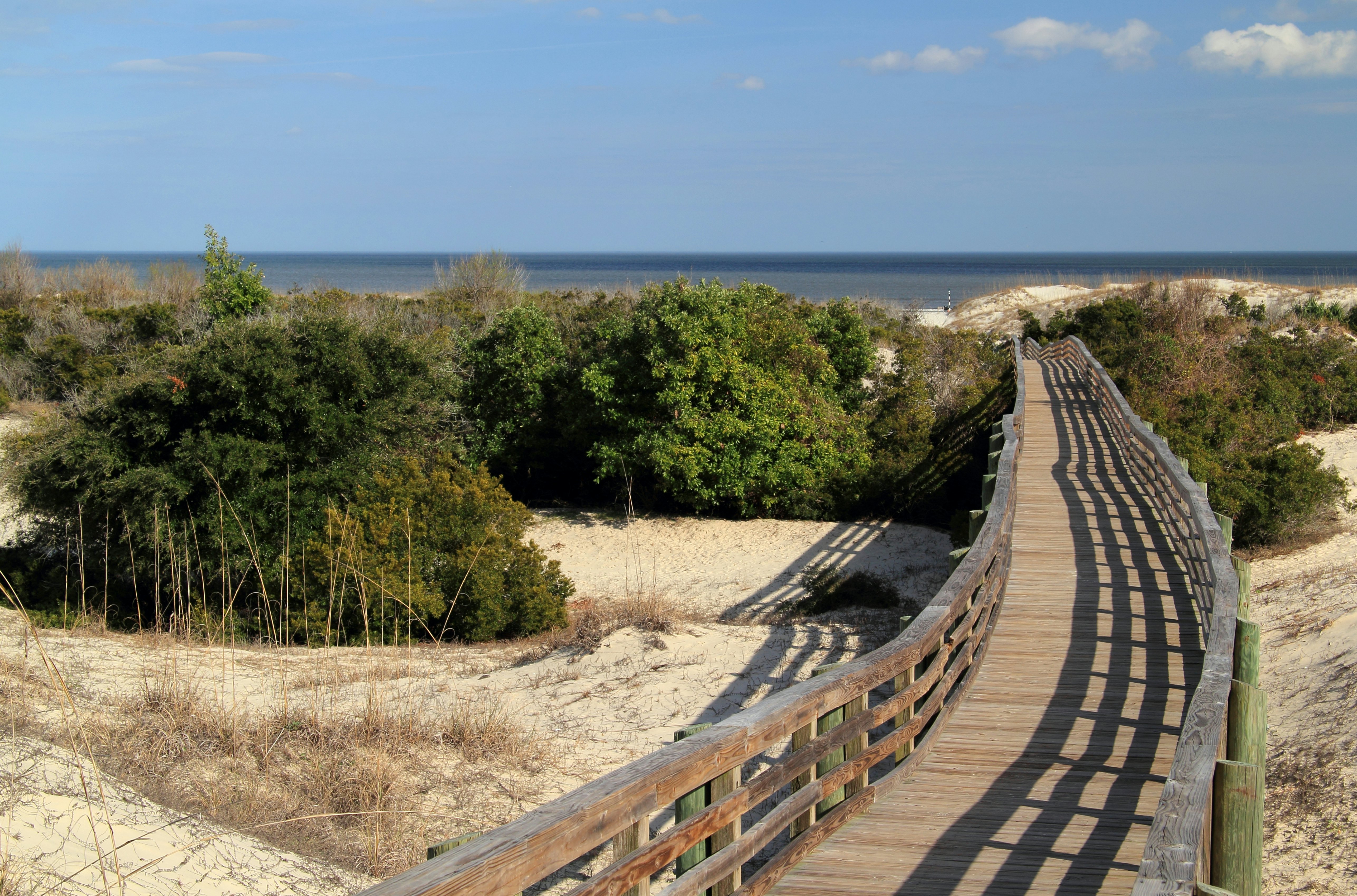
5. Georgia: Cumberland Island National Seashore
Best for quiet coastal beauty
Start and end: Sea Camp Dock via 45-min ferry from St Mary’s, GA
Length: from 21 miles round trip
Time commitment: 4 days
Difficulty: easy
A nostalgic vibe drifts across Cumberland Island. Maybe it’s the magnificent live oaks. Or the abandoned grand mansions. Or the scruffy wild horses that wander the empty beach. Whatever the cause, this barrier island off the coast of Georgia is a special place well-suited for backpackers seeking beauty, history and seclusion.
From Sea Camp Dock, it’s a 7.5-mile backpack to Yankee Paradise, one of three wilderness campsites in the northern reaches of the island. Guided tours explore nearby Plum Orchard Mansion, a former haunt of the Carnegies. The next day it’s a 3-mile hike to Brickhill Bluff for two more nights of wilderness camping. The remnants of The Settlement, a community built by formerly enslaved people, are close to camp. John F Kennedy, Jr, and Caroline Bessette were married at the tiny First African Baptist Church here in 1996. Spend your last night at Stafford Beach Campground, which is a quick 3.5 miles from the dock.
Where to stock up: Buy coffee, pastries and sandwiches at Kraken Coffee and Kitchen in St Mary’s.
Need to know: Reserve campsites ($9 to $22 per night) up to six months in advance. There is a fee for park admission ($15 per person) and the ferry (adult/child $40/30 roundtrip). Spring and fall are the most popular seasons for camping.
Wrapping it up: Fill up on big shrimp and raw oysters at St Mary’s Seafood.

6. Great Smoky Mountains National Park: Charlies Bunion and Kephart Loop
Best for naturalists and history buffs
Start and end: Newfound Gap Parking Area
Length: 14.1 miles
Time commitment: 2–3 days
Difficulty: moderate
The viewpoint known as Charlies Bunion in Great Smoky Mountains National Park is far more impressive than its unfortunate name suggests. A rocky outcrop on the Appalachian Trail (AT), it overlooks a rolling tableau of deep valleys framed by forested slopes. Home to more than 19,000 documented species of animals and plants, the park – which shimmers in every shade of green in spring – is the most biodiverse in the entire national park system. The quiet Kephart Loop drops you deep into this verdant wonderland, thick with creeks, mosses and riparian plant life.
From Charlies Bunion the loop drops beneath archways of Catawba rhododendrons on the Dry Sluice Gap Trail before linking to the oak- and birch-lined Grassy Branch Trail. The Kephart Shelter camping area borders Kephart Prong Creek in a hardwood grove that was once the site of a lumber camp. An abandoned Civilian Conservation Camp is nearby. From here the Sweat Heifer Creek Trail passes multilevel cascades on its climb back to the AT. You can also camp at Icewater Spring Shelter, an AT campsite between Newfound Gap and Charlies Bunion.
Where to stock up: Head to Food City in Gatlinburg for groceries. You can buy camping gear at Nantahala Outdoor Center near the north entrance of the park.
Need to know: You must have a permit ($8 per person) for overnight stays. Reserve ahead at smokiespermits.nps.gov. A parking tag (daily/weekly $5/15) is required.
Wrapping it up: Celebrate with burgers and craft beer at Smoky Mountains Brewery in Gatlinburg.
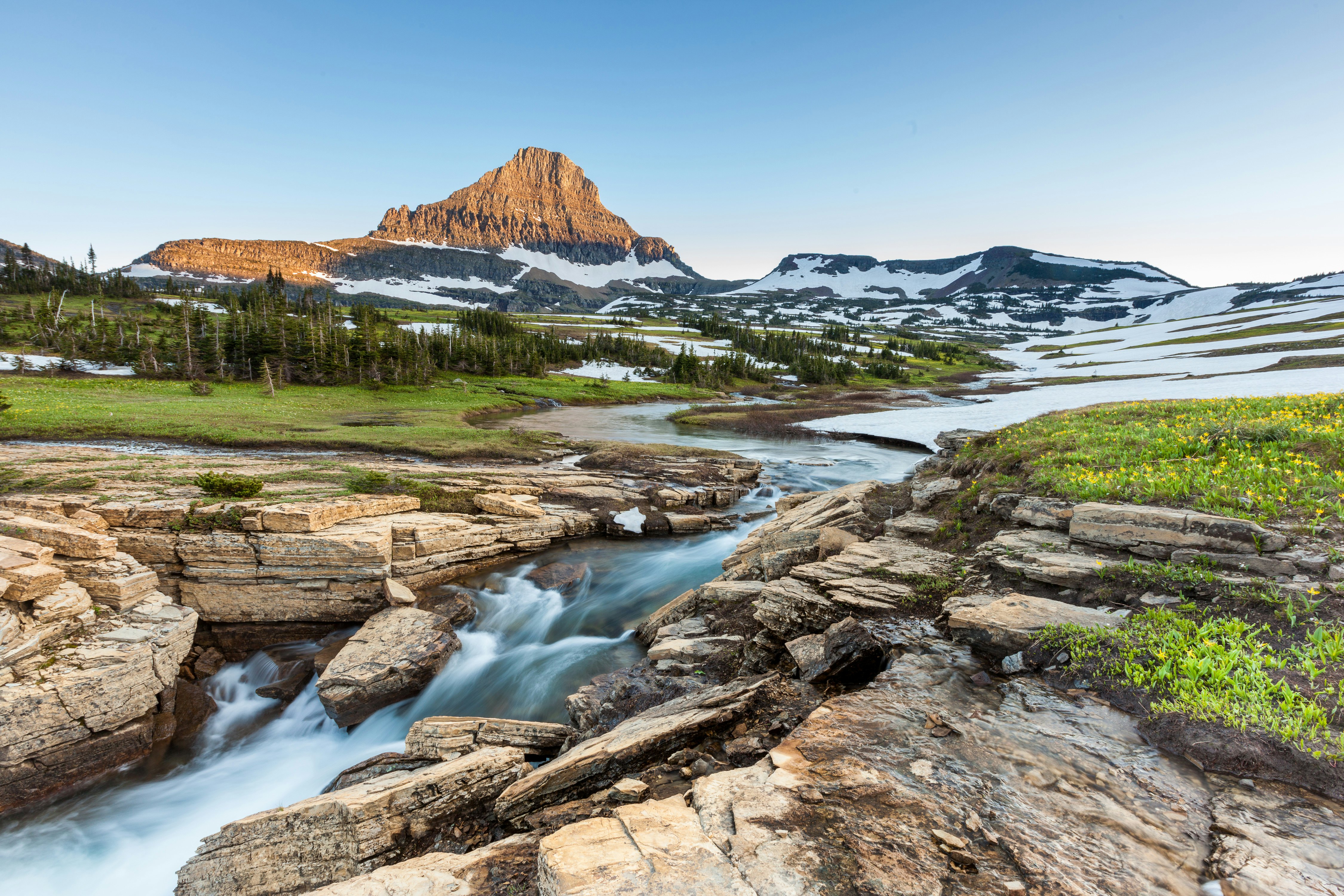
7. Glacier National Park: Highline Trail
Best for glacier views
Start and end: Logan Pass to the Loop, both on the Going-to-the-Sun Road
Length: 11.8 miles, 13.6 miles with Grinnell Glacier
Time commitment: 2 days
Difficulty: moderate
This one is a cheat since you can sleep in a lodge, but we can't leave out the Highline Trail. There’s an actual glacier along the way! And maybe bighorn sheep. This invigorating walk in the Rockies greets you at Logan Pass with trailside wildflowers then swooshes you onto the Ledge, a sliver of trail teetering 100ft above the Going-to-the-Sun Road. From here it's a walk beneath the towering Granite Wall along the Continental Divide, with Alp-like peaks framing the trail ahead. A detour climbs to an otherworldly view of Grinnell Glacier.
At 7.6 miles you’ll reach Granite Park Chalet. It’s not a campsite, but you’ll carry linens, overnight clothes and other necessities to this spartan, 12-room lodge with bunk beds. Backpackers can camp at the nearby Granite Park Backcountry Campground. From the chalet, hike 4.2 miles to the Loop shuttle stop.
Where to stock up: Stop by West Glacier Mercantile for groceries and sandwiches.
Need to know: In 2025, access to the Going-to-the-Sun Road from the west requires a timed entry reservation ($2 fee; mid-Jun-late September; 8am–3pm). Grizzlies roam the area, so hike in groups and carry bear spray. Reservations for Granite Park Chalet open in January and typically sell out the first day.
Wrapping it up: Treat yourself with a sandwich and a slice of pie at LouLa’s Cafe in Whitefish.
Advertisement
Take your United States (USA) trip with Lonely Planet Journeys
Time to book that trip to United States (USA)
Lonely Planet Journeys takes you there with fully customizable trips to top destinations – all crafted by our local experts.