Advertisement
Coasts, Castles and Culture: Nine days on Ireland’s Wild Atlantic Way
Sponsored by
Tourism Ireland

Bailey Freeman
May 20, 2024 • 12 min read

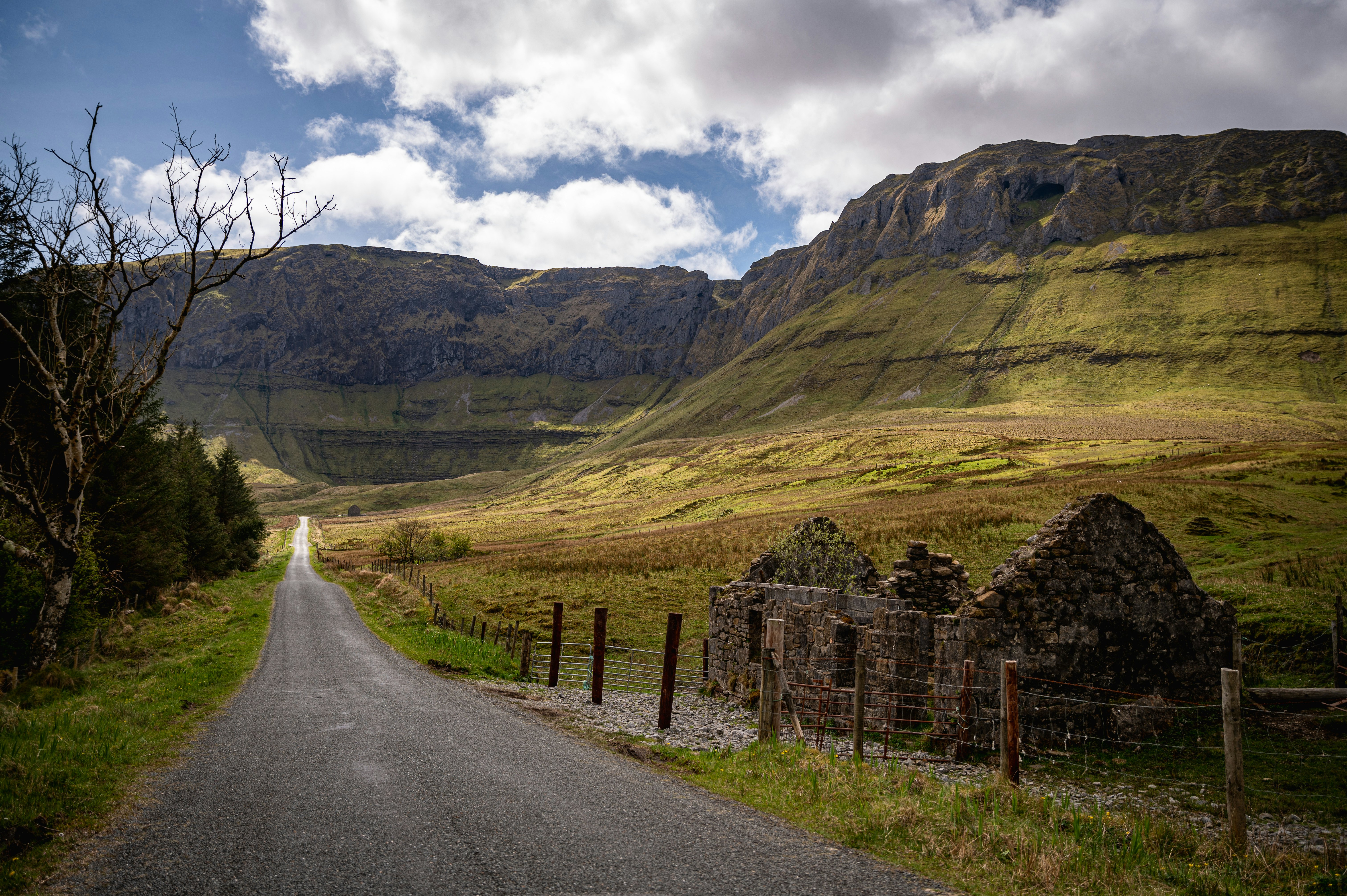
This itinerary takes you up the Wild Atlantic Way county-by-county – a thrilling route that encompasses adventurous hiking trails, scenic overlooks, foodie stops, history from the Bronze age to WWII © Robert Ormerod for Lonely Planet; Graphics by Dustin Johnson / Lonely Planet
There’s no doubt about it: Ireland's Wild Atlantic Way is one of the best road trips in the world. A delightful amalgamation of wind-warped cliffs, emerald hillsides, ancient historic sites and quintessentially Irish coastal towns, this 1500-mile journey takes you through many of the island’s superlative destinations.
Follow our itinerary as we take you up the Wild Atlantic Way county-by-county, a thrilling route that encompasses adventurous hiking trails, scenic overlooks, foodie stops, history from the Bronze age to WWII, and of course, plenty of opportunities to sip a creamy pint of Guinness at the end of the day.
You can hit many of the highlights in eight or nine days, but with two weeks or more you can savor the experience from start to finish.
From our partners: Ireland’s Wild Atlantic Way

We recommend flying into Shannon Airport outside of Limerick rather than arriving in Dublin; from this gateway to the Wild Atlantic Way it’s a straight shot to the south coast and the delightful coastal town of Kinsale. Stretch your legs and grab a pastry from a cozy cafe (like Seeds Bakery) or pop over to a couple of nearby castles – James Fort and John Charles Fort sit a stone’s throw away.
From here, head west along the winding roads of County Cork, making a pit stop at Drombeg Stone Circle, a megalithic burial site overlooking a mind-bendingly green piece of Irish countryside. The site is dated between 152 BCE and 127 ACE, and it’s one of the island’s most well-preserved stone circles.
Advertisement

Further west you’ll find Skibbereen, a market town that serves as a good base for exploring western Cork; from here it's a quick hop to the coast, where you can hit the water with outfitters like Atlantic Sea Kayaking in Lough Hyne and H2O Sea Kayaking, which explores nearby Sherkin Island. Down the road is bohemian Ballydehob, home to bar/music venues like Levis Corner House, art studios, cafes and crafters spaces (don’t miss Kilcoe Studios or Artichoke).
Continue west to see Mizen Head, Ireland’s southernmost point, or cut north through the hill-flanked harbor town Bantry and the neighboring Caha Mountains to Kenmare, a buzzy burg that serves as a great introduction to County Kerry; if you’re in need of refreshment, stop into Kenmare Brewhouse for coffee, food and traditional tunes in the evenings.
Either spend the night here or head up to Killarney.
From our partners: Wild Atlantic Way in Cork

For many, County Kerry is the most beautiful region in a land teeming with beauty – encompassing a deep roster of signature sights that fill itineraries far and wide.

Start your pilgrimage to this treasured corner of Ireland in Killarney, a well-rounded town adjacent to Killarney National Park, the island’s first national park and a UNESCO Biosphere Reserve. This expansive protected land contains medieval ruins (Muckross Abbey), polished estates (Muckross House) and miles of trails tracing ancient forests and imposing mountains, all abutting the scenic lakes that run through its core.
After you’ve soaked up the park’s vistas, head for one of Ireland’s most famed routes, the Ring of Kerry, to dig into the countryside. Explore villages and beaches along the way (we’re partial to Sneem and Derrynane Beach), before following the narrow, walled roads of the Skellig Ring. Here, you’ll experience the rush of standing on the towering Cliffs of Kerry and the views of the galactically famous Skellig Islands – as pictured in Star Wars: The Force Awakens and Star Wars: The Last Jedi.

Make your way back onto the Ring of Kerry and head around the peninsula to access the stone forts near Cahersiveen, which are thought to be from the Iron Age or the Early Historic Period. From there, drive north and swing onto the Dingle Peninsula, crashing in friendly Dingle Town before commencing the next leg of your adventure. Shop for art from local makers and grab some seafood from The Fish Box or Michelin-recognized Out of the Blue before bedding down for the night.
From our partners: A trip around the Ring of Kerry

Dingle Peninsula has everything – epic coasts, sweeping green hills, tons of cultural stops – and you can sample it all on a single, relatively short loop known as the Slea Head Drive.
Things start relaxed with Ventry Beach and a few historic sites (including beehive huts), but the peninsula puts on a show once you pass the oft-photographed white cross at its southwestern corner: stop at Coumeenoole Beach and Dunquin Pier to admire the dramatic rock faces and the nearby Blasket Islands. Don’t miss the Blasket Center, a lovingly curated museum highlighting the island village that existed on Great Blasket until the 1950s; the community was famous among linguists as an important enclave for the Irish language, and despite its tiny size, it churned out several published authors.

The loop’s return takes you back to Dingle town – from there you’ll swing north across the spectacular Conor Pass, Ireland’s highest mountain pass (the best photo op is at the parking lot on the Dingle side). And then its onwards to County Clare, hooking back up past Limerick and over to the island’s best known section of coastline, the Cliffs of Moher. Some things are favorites for a reason, and the cliffs’ scalloped silhouettes definitely wow you; plus, it’s interesting to see how they compare to the Cliffs of Kerry and Sliabh Liag (more on that one later).
Several nearby towns offer respite after a long day of driving. We like Ennistymon, a charming town centered around a tiered waterfall with the elegant Falls Hotel at its base.
From our partners: 72 hours in Ireland’s stunning southwest
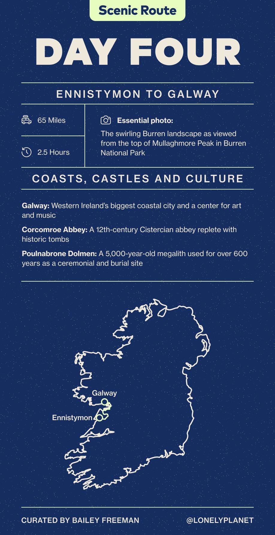
From Ennistymon, it’s on to the region known as the Burren. An ancient seabed revealed and shaped by the elements, this limestone landscape ripples and folds like it was molded by magical forces. It’s home to 70 percent of Ireland’s plant species (including 23 types of orchid), and these tiny miracles reveal themselves between the cracks in the stone: purple orchids, cowslip, purple gentian, shrubby cinquefoil and more. Hike the trails of Burren National Park to experience this region in high definition; the view from Mullaghmore Peak is wondrous.
Advertisement
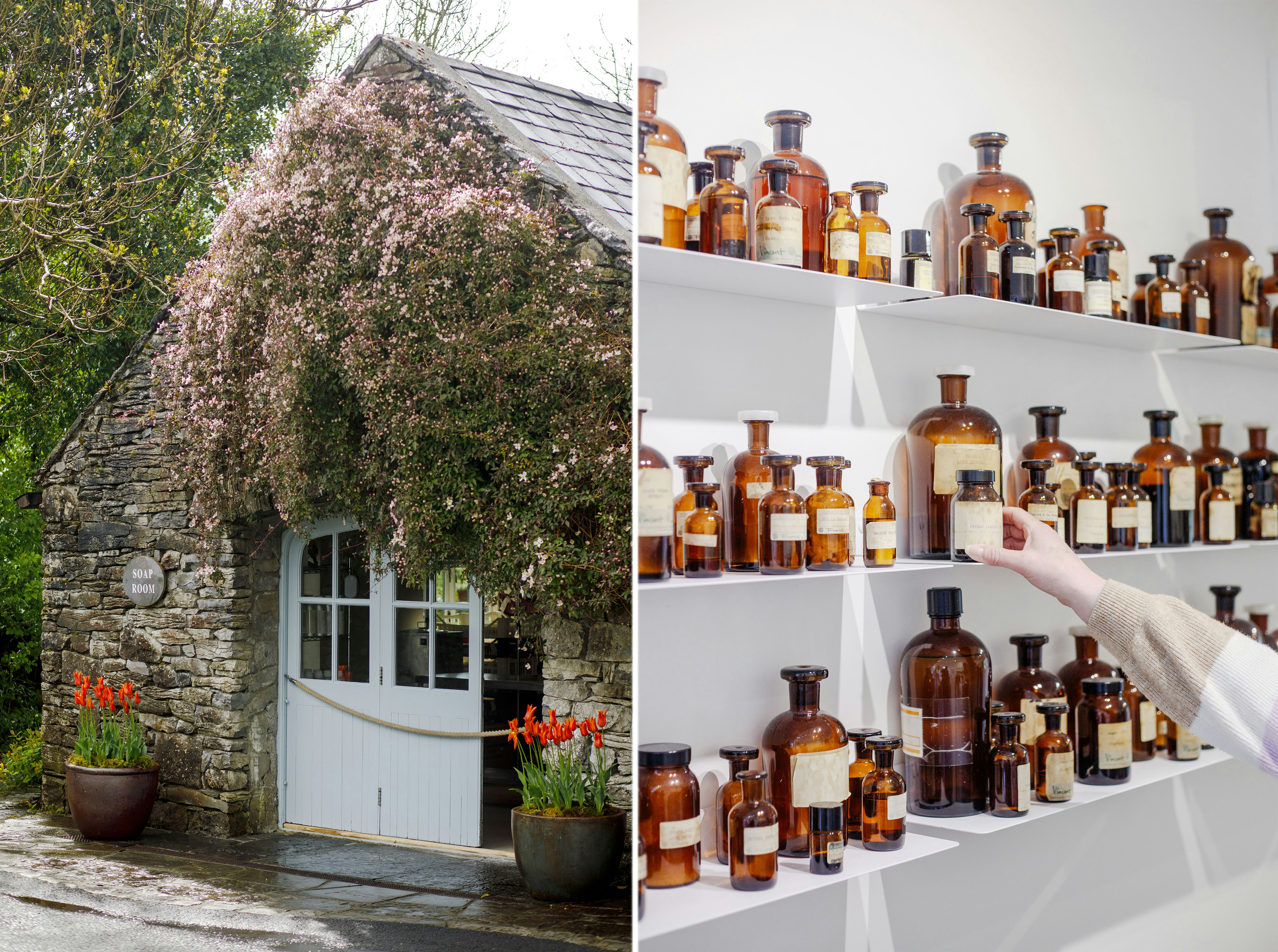
After you’ve experienced the magic of the Burren on the trails, head to Burren Perfumery, which makes original fragrances inspired by the region’s flora. Spend some extra time here to sample treats from the adorable tearoom, which serves tea made with garden-grown herbs, top-tier sweets and a short lunch menu – order the pistachio rose cake immediately.
The Burren region is also home to plentiful remnants of human history dating to the Stone Age; stops include stone forts like Caherconnell (worth a visit for its sheepdog demonstration, too), passage tombs like the famous Poulnabrone Dolmen and medieval ruins like moody Corcomroe Abbey, constructed in 1194.
From there, make your way to the spirited cultural hub of Galway city – spend some time decompressing along the canal, sample the fish cakes and oysters at Hooked and settle in for an evening of traditional music at the famous Crane Bar.
From our partners: The Burren

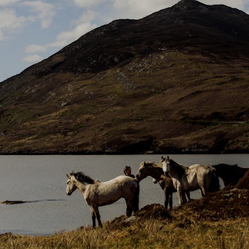
We’re off to the famed mountains of Connemara, a region known for its green marble, its unique breed of ponies and, of course, its gorgeous landscape.
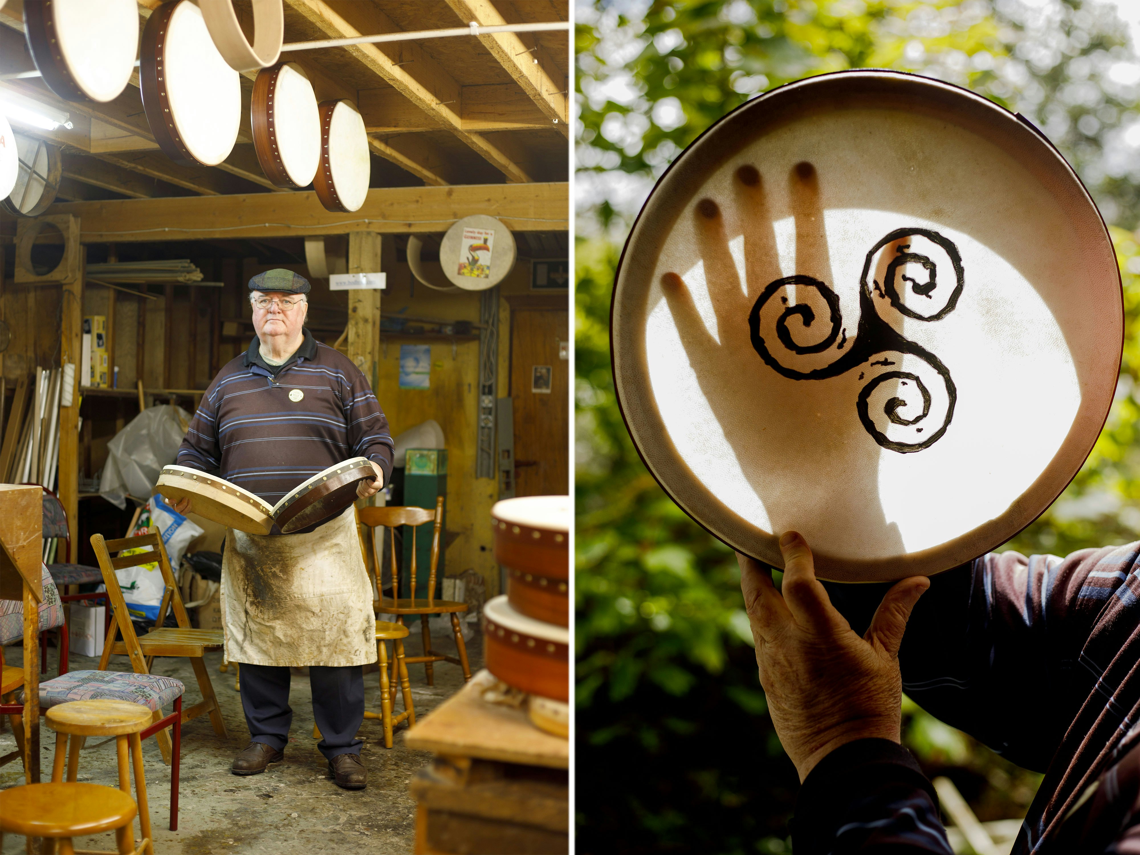
Head west from Galway, stopping in at the Spiddal craft village to meet potters, jewelry makers and traditional basket weavers. In keeping with the craft theme, loop around this lake-studded part of Ireland until you get to the seaside town of Roundstone, home to Roundstone Music & Craft; here you’ll meet local legend Malachy Kearns, a drum maker who has been building bodhráns (traditional Irish drums) for nearly 50 years. He’s a born storyteller, so stay a while and learn about how he worked with Riverdance creators to develop the production’s signature drum.
It's a short drive to the heart of the Connemara region – cute Clifden provides a staging point for cycling on the scenic Sky Road or around Erislannon, where you can also ride the famous Connemara ponies. The town is also a short hop from Kylemore Abbey, a castle-turned-monastery that offers daily tours through its manicured grounds.

If you want to get closer to the mountains themselves, make your way to Connemara National Park; the climb up to Diamond Peak reveals sweeping views of the mountain-bog combo that defines the ecology of this area. You won’t be alone on the trail, but the company doesn’t detract from the views.
There are several options for overnighting close by: head back to Clifden or opt for B&Bs in Letterfrack and Renvyle.
From our partners: Connemara

Hope you got a good night’s sleep – it’s a big day! Hit the road to County Mayo, a scenic route around the mountain-lined Killary Fjord that takes you up through the Doo Lough Valley, an area of immense natural beauty.
Once you exit the valley, circle back on country roads to the glorious Silver Strand; a walk across the flat expanse of sand reveals rocky promontories home to tidepools full of thriving critters. Silver Strand is one of Mayo’s many sandy beaches; if you’ve got a flexible schedule, take your time discovering them all.

Next is the drive north to Westport, a colorful town that sits at the heart of a sophisticated bike network – you’ll be sharing the road with lots of cyclists, so stay alert at the wheel. Grab lunch (like the lovely beetroot sandwich at Kaska’s) and jump back in the car to make your way to Achill Island. Part beach resort, part history museum, part nature park, Achill has something for everyone: check out the Kildavnet Tower (an outpost belonging to Grace O’ Malley, Ireland’s famed “Pirate Queen”), spot a basking shark at the cliff-lined Keel and Keem beaches, or wander the ghostly remains of a village vacated during the famine of 1845-1852.
Drive back up to the mainland and hit N95, which takes you up the Ballycroy side of the Wild Nephin National Park. If you’ve got energy left, go for a short walk on the lovely Claggan Mountain Coastal Trail, a well-kept boardwalk hovering over Ireland’s coastal boglands.
Overnight in or around Sligo for the perfect starting point for your next leg.
From our partners: Explore from Westport, County Mayo
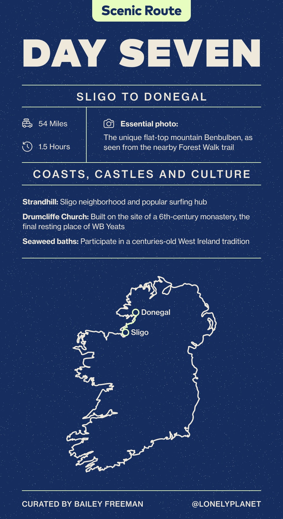
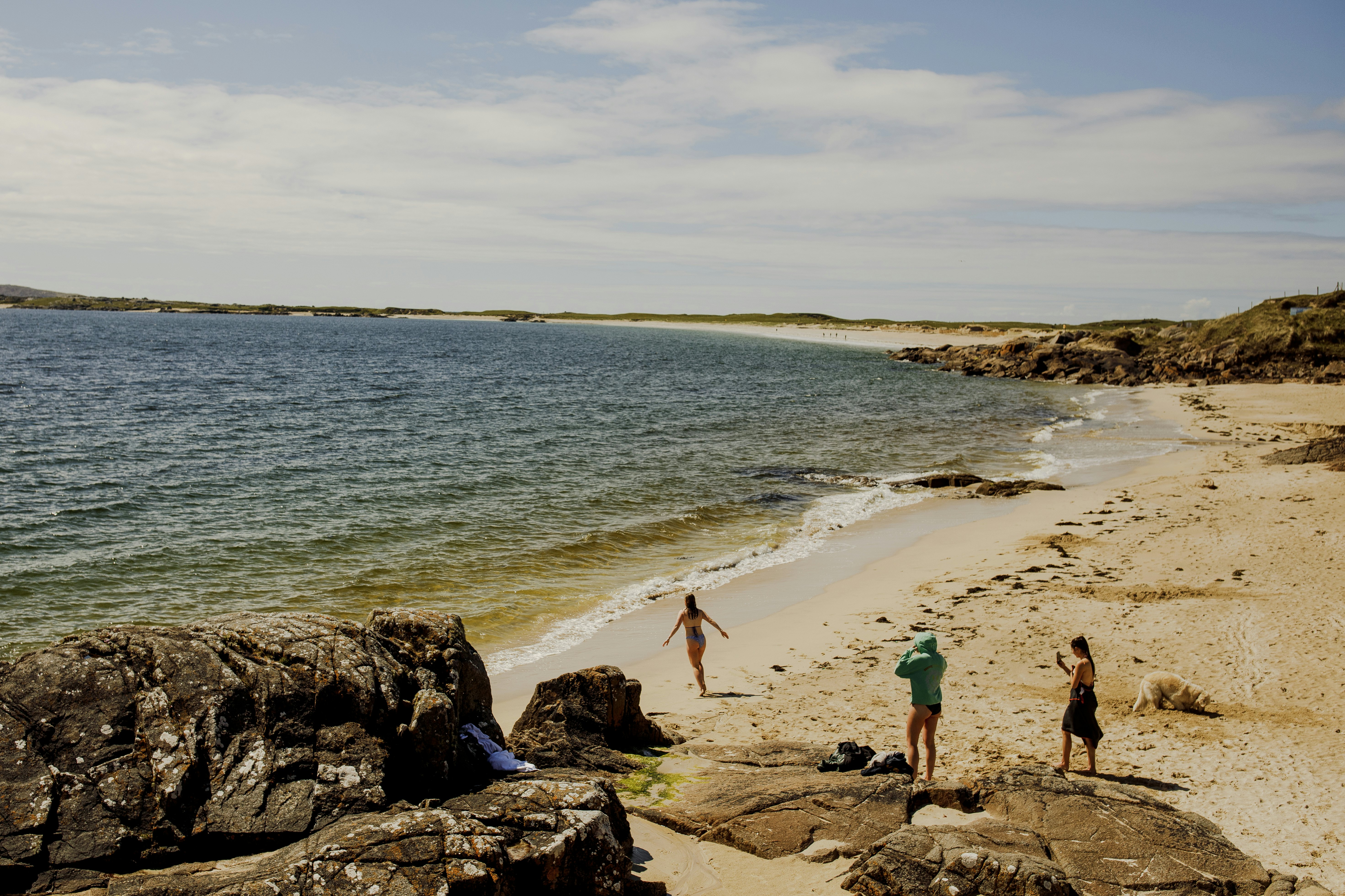
After covering some serious real estate through County Mayo, you’re due for a more relaxed day and the area around Sligo is just the ticket. Strandhill, just 15 minutes from Sligo’s center, delivers excellent surf town energy; sit on the plaza wall to watch surfers glide along the waves, or grab a board yourself and hit the water with Strandhill Surf School. Looking for something more low-key? Go full mermaid and book a seaweed bath at Voya Seaweed Baths, a local tradition dating back hundreds of years.
Pop into Sligo town to get your bearings before making the short drive to Drumcliffe Church; one of Ireland’s most famous sons, WB Yeats, is laid to rest here, and the atmospheric churchyard has been lovingly preserved; there’s also an airy cafe and local art shop on site. From here, we recommend the Benbulben Forest Walk, a leisurely trail with staggering views of the iconic flat-top mountain that defines the region’s “skyline;” the path also takes you through wondrous sections of forest and offers top-down vistas of the coast.
If you can’t get enough of the region’s unique mountain scenery, take a spin over to Gleniff Horseshoe, a prehistoric-feeling valley encased in vertical cliffs straight out of a fantasy world. Drive around the one-lane loop at its heart and pop into the Gleniff Barytes Mill Site, a charming stop that pulls double duty as a historic site and sculpture park – see if you can find the fairy doors.
Donegal town is your final destination for the day. If you’re a history buff, arrive with enough time to tour the Donegal Castle; shoppers, make a beeline for Magee 1866 for a piece of your own iconic Donegal tweed. There are lodging options in town, but we recommend checking out the B&Bs around nearby Lough Eske for a scenic place to rest your head.
From our partners: County Sligo

As we enter the sprint to the finish on the Wild Atlantic Way, County Donegal pulls out all the stops. From Donegal town, head west to Sliabh Liag, Ireland’s tallest accessible cliffs and this writer’s absolute favorite. The nearly 2,000-foot-tall cliffs boggle the mind – both the roadside walk to the viewpoint and the trail winding up and over the cliff faces deliver Donegal writ large.
Once you come down from your Sliabh Liag-induced adrenaline spike, make your way through the astonishing Glengesh Pass to Maghera Beach, home to its namesake caves and some of the most beautiful beach views on the Wild Atlantic Way. Note: bring €3 for parking and do not explore the caves without checking the tides first, as they are only safe to access when the tide is out.

From here, head inland to the northernmost national park on Ireland’s western side: Glenveagh National Park. Situated around a glaciated valley in the Derryveagh Mountains, the park is a serene place to explore – history buffs will enjoy Glenveagh Castle, accessible by park shuttle booked upon arrival, while hikers can choose from a few different trails that wind through the glen and its hillsides.
Nearby Letterkenny is the county’s largest town and a good place to base yourself for your final day on the road: grab dinner at The Yellow Pepper and stop in for some music at McGinley’s.
From our partners: Donegal’s northern headlands

This is it: your last day on the Way. Head north to Five Finger Strand for your final glimpse of Ireland’s signature windswept beaches before crossing the finish line at Malin Head, the island’s northernmost point. Walk the trails of the promontory to see the Atlantic crash against weather-ravaged cliffs, and loop back up to the signal tower dating from the early 1800s for a dose of history. You’ll spy the “Eire 80” sign that was placed here to let WWII pilots know they were passing over neutral Ireland.

After you’ve had your fill of final Atlantic views, it’s time to circle back down to Shannon and Limerick for departure, a five-hour drive. Once there, say goodbye to your epic journey with a pint at Treaty City Brewing, located in the town’s fascinating Medieval Quarter adjacent to King John’s Castle, and a meal overlooking the River Shannon at The Curragower.
From our partners: Discover King John’s Castle

Things to know about driving the Wild Atlantic Way
Ireland is spectacular to visit any time of year, but traveling in fall usually means fewer crowds, mild weather, stunning landscapes and cozy stops.
Double check your car insurance before heading out – you may need to purchase additional policies from your rental company upon arrival.
Sections of the drive are on narrow country roads that feature some blind corners. That’s part of the fun! But drive with care.
Be sure to top up your tank whenever you get the chance. American drivers: unleaded gas is labeled green while diesel is labeled black, opposite to the colors at home.
You might also like: Epicurean adventures along the Wild Atlantic Way
Sponsored by Tourism Ireland
As a travel entertainment and inspirational media outlet, we sometimes incorporate brand sponsors into our efforts. This activity is clearly labeled across our platforms.
This story was crafted collaboratively between Tourism Ireland and Lonely Planet. Both parties provided research and curated content to produce this story. We disclose when information isn’t ours.
With sponsored content, both Lonely Planet and our brand partners have specific responsibilities:
-
Brand partner
Determines the concept, provides briefing, research material, and may provide feedback.
-
Lonely Planet
We provide expertise, firsthand insights, and verify with third-party sources when needed.
Advertisement
Take your Ireland trip with Lonely Planet Journeys
Time to book that trip to Ireland
Lonely Planet Journeys takes you there with fully customizable trips to top destinations – all crafted by our local experts.